It was Good Friday. Thankfully. For the previous two weeks had not been good for the Rotorua Lakes Council.
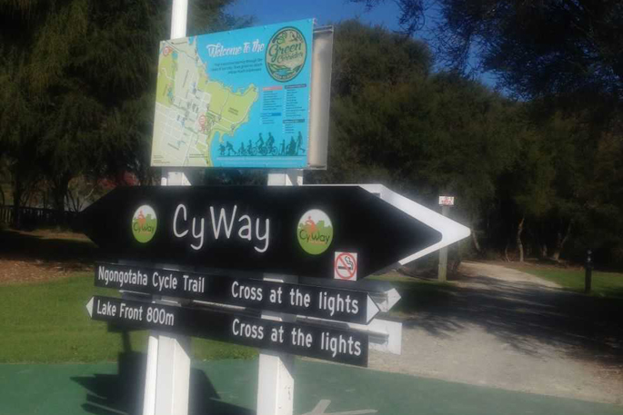
Councillors were told the grim but not surprising news CyWay through the CBD may be a lost cause.
The heavily promoted kinked route through town had not worked out.
Hannibal's elephants had a much less torrid ride through passes in the Alps than cyclists through the bustle of Rotorua retail shops.
The elephants used instinct, cyclists contemplating the CyWay bit through town could read signs. On a bike even at slow speed, strategically placed directions at doglegs, porcine legs and Lego legs are a difficult focus.
Because they compete with other signs, or cyclists have to rely on intuition, your ride can become awfully disruptive.
To the relief of local businesses affected by route sublimations to cater for the cyclists, the short, demanding route through town is again under contemplation. Haupapa and Hinemoa Streets may soon return to their former, original states.
Twice the council re-arranged the western end of Haupapa Street to accommodate the cyclists which led to retailer howling wolves aghast at probable income reduction.
Cycle routes on both streets are presently channeled between the main footpaths and angle parks. In Haupapa Street, the route is colourfully painted with serpentine railway track over imaginary streams etc to illustrate the richness of eco diversity.
This section of the CyWay which has caused so much controversy over so few who use it is barely 0.5 kms long – protracted by care and share limitations, sharp corners as the route takes the rider from Kuirau Park in the west to the fringes of the Sanitorium Reserve to the east.
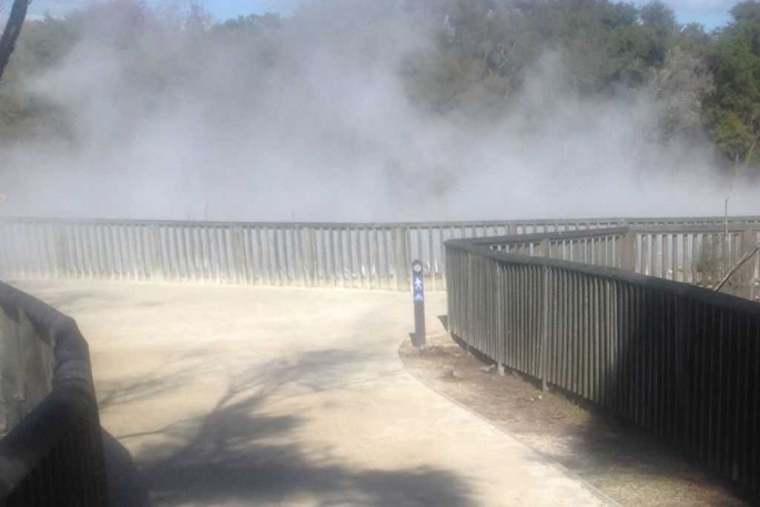
On Good Friday, this correspondent rode the whole trail from Ngongotaha to the Redwood Forest. Once out of the claustrophobic CBD (by building not through population pressure) the cyclist moves quickly into solitude on either west or east or from Ngongotaha south to the Redwoods. For 1km of this trip, the cyclist or pedestrian rides alongside a busy highway – in this instance Lake Road, which enters the spectacular and picturesque Kuirau Park.
For some, this is where the cycle ride begins. For around 400m, on certain days as long as tourists aren't in the way, the cyclist can whiz along, or locomote sedately to take in the best free show in town.
Rotorua's natural beauty is compressed into one small whole – geysers, fissures, steam, mud and solid walkways overlooking excessive areas of cauldron, redolent of Macbeth's double, double toil and trouble. At various points, native trees, a totem representative of a taniwha, that mythical beast.
Where necessary, signs stand adjacent to the trees with precis of the antecedents and background and use of such as manuka, kahikatea and other natives.
A UK visitor suggests one area could be named Shrewsbury Copse, in recognition of the famous biscuit (better known as jammie dodgers in the UK), for the pathway circumnavigates a tree.
Tourists thicken. Selfies in profusion. People walking backwards. Families group for family selfies (or our selfies!) in front of man-made areas to record their time amidst the mists….
The cyclist emerges on a common, concrete area, past an old brick building utilised as latrines, as a garage for council working tools and implements, and, for two weeks each month, Friends of the Library sales.
Once the CBD is negotiated, the route takes another turn – for toward the east the Sanitorium Reserve, in which were recently discovered, takes the cyclist towards and alongside the frenetically busy Te Ngae Road highway. Here pedestrians and cyclists brush as much with nature as they heavy traffic, out of view from the road.
The tracks (and there are options) takes one through to Puarenga Stream near the site of the waste water treatment station, or the Puarenga Reserve, on which this day two games of reasonably serious cricket were being played.
Past the treatment station (and travel no faster than 15kph if you please) a left turn swings around to the fringes of Lake Rotorua or, to the right, towards Te Ngae road, under the bridge and to the majestic Cedric Rogers trail.
The late Cedric introduced the walking bus along Te Ngae Road; he died suddenly some 10 years ago, his memory enshrined by a wide, open pathway of nearly 1km which takes the rider/walker to Longmile Road, a sharp turn to the right to the Redwood tree tops walk.
The ride is peaceful; in composition it does remind one of Whirinaki Forest some distance south of Rotorua in which nature remains unfettered.
Overall, a classy ride – the openness from Ngongotaha to Lake Road; the enshrouding mists of nature through Kuirau Park; the fitful cloister of the CBD; the natural character of the track to Puarenga; and clement finish through Cedric Rogers Drive to the Redwoods.
And return.
A story for another time.
Rotorua cycle facts include:
■ Rotorua has 11 cycleways, costing $5.5million to construct.
■ Cost is shared: Rotorua Lakes Council (RLC), $1.9m; Government urban cycleways, $1.5m; National Land Transport Fund, $2.1m.
■ 2018-2028 Long-Term Plan enhancements up to $1m each year, 55% covered by the NZ Transport Agency.
■ The RLC is responsible for 650kms of footpaths.
■ Specific allowance of $500,000 to replace parts of whole footpaths.
■ Goal is to cut carbon emissions and activate modes of transport like cycling and scooter use to also reduce congestion.

0 comments
Leave a Comment
You must be logged in to make a comment.