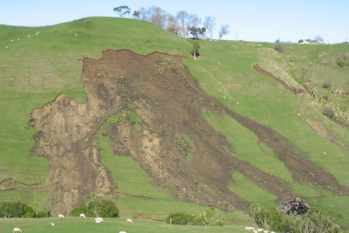
As severe storms and significant weather events continue to increase in New Zealand, so does the amount of erosion.
According to the Ministry for the Environment's our land 2018 report, almost half, 44 per cent, of this loss is from pastoral land.
A new collaborative five-year MBIE funded programme ‘Smarter Targeting of Erosion Control' led by Manaaki Whenua Landcare Research is now underway, with the task of exploring cost-effective ways of targeting land-based erosion control in the hope of slowing the damage and improving water quality.
'This research will improve our understanding of where erosion occurs, sediment volume, what type of sediment is produced, and by which processes,” says Manaaki Whenua Landcare Research Geomorphologist Dr Hugh Smith.
As significant weather events continue to increase, so does the amount of erosion – triggering the urgent need for research to understand how to best target erosion control to slow the damage and improve water quality.
Fine sediments are the most common culprit behind widespread contaminants in New Zealand's rivers and estuaries. They muddy rivers and reduce water quality, but also carry other pollutants such as heavy metals, nutrients and microbes.
'Year to year there is large variability in storm events,” says Hugh.
'We have severe storm events like the one in 2004 in the Manawatu River where huge quantities of sediment are generated and flow down the river, and there are massive impacts from landsliding and flooding.
'Then other years we have extended low rainfall periods with no major storms and less sediment, but the water quality is still quite troubling,” he says.
Current erosion modelling tools model annual average sediment loads over entire catchments but through STEC new data will be collected and used in building new models.
'Our ambition is to move from steady-state annual models where things are currently treated on a long term annual average using historical rates of change, to an event scale modelling approach that better links erosion sources to the fine sediment affecting water quality in streams and rivers,” says Hugh.
The models will indicate how sediment, and in particular fine sediment, moves through catchments and how erosion and sediment transport can be targeted and mitigated cost-effectively to help strategically minimise erosion effects.
'The smarter targeting of the whole STEC programme is saying ‘well if we had better data, and better models that allowed us to actually link erosion on the land to instream related water quality impacts could we then better inform managers when it comes to deciding where to target their investment in erosion control to maximise the benefits downstream?” he says.
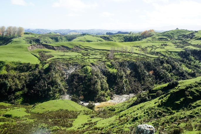
STEC is starting sampling in four river catchments across New Zealand to collect this new data. The Manawatu – for new and continuing data collection; the Whanganui – to look into impacts from the 2018 storm and legacy sediments; and the Oreti in Southland and Wairoa near Auckland – to research bank erosion and sediment fingerprinting methods in collaboration with NIWA's Managing Mud programme.
Erosion mitigation research will also be conducted on farms to learn more about how effective erosion techniques are, and build on the base of research for new models.
'Once we have an operating model, there is the opportunity to run scenarios and look at questions relating to the targeting of erosion control and the benefits at a catchment scale,” says Hugh.
'We will then link in with the economic analysis and include that as part of the equation so we can get a fuller view of the wider benefits of an erosion control strategy and be able to predict outcomes for different catchments.”
Sampling is already underway in the Oreti and Manawatu in the upper Tiraumea catchment – where sensors are being installed into earth flows to provide data on the rate of movements. A weather station will also be installed to look a climate conditions and how they vary and relate to movement rates.
Further erosion sampling will take place over the coming months and continue for three years.

0 comments
Leave a Comment
You must be logged in to make a comment.